In this lesson, students focus on how erosion shapes Earth’s surface. They use that knowledge to analyze how the matter that makes up rocks is shaped and reshaped by the rock cycle. This in turn transforms Earth’s surface over time.
In this unit, students stimulate the movement of tectonic plates and analyze maps to observe how plate boundaries create patterns in Earth’s features. In this lesson, they build on that knowledge to observe the science phenomenon of how water erodes sediment. This page highlights key components of this lesson.
Science background gives educators more in-depth information on the phenomena students explore in this unit. Below is an excerpt from the science background information for this lesson on water erosion.
The movement of two tectonic plates converging on each other caused the rocks of the flat, featureless plain in what is now Arizona to lift up high and flat. This had the effect of creating a plateau surrounded by mountain ranges. Water, which always flows downhill because of gravity, began flowing from the mountains across the plateau and forming the Colorado River.
The Grand Canyon first came into existence about 5.5 million years ago when the Colorado River began to carve its way down the plateau. Scientists still don’t fully understand why the river took the path it did or exactly how it was able to carve a canyon of such dramatic dimensions.
However, scientists do generally agree with the basic processes that have shaped the canyon. Every day, the Colorado River can carry almost 500,000 tons of rock and debris. It is so powerful because it has kinetic energy—the energy of motion. Wind and moving water are able to weather and erode the land because of the energy they have in their movement.
Gravity plays a major role in how deep the canyon is. There is a steep drop-off between the plateau and the ground. For every mile the river travels, it falls 10 feet. As it falls, it converts gravitational energy into kinetic energy. The width of the canyon can be explained by the layers of rock that are exposed. Exposed rock is constantly being weathered and eroded by rain and wind.
These processes that formed the canyon continue today, repeating over and over. This means that the canyon is continuing to change, and will likely look very different in a million years from today.
Most of the rocks in the Grand Canyon are a kind of rock called sedimentary rock. Sediment is a collection of solid particles of rocks, minerals, and the remains of plants and animals. It is deposited on top of other layers over time. Over thousands of years, the pressure of more and more top layers of sediment compresses the bottom layers of sediment into solid rock. The oldest sediment forms the bottom-most layers of the rock. Newer layers replace older layers at the top.
Each layer in a sedimentary rock formation represents a period of time, often with different climate or geography. Scientists can read the properties of the rock, including size, shape, and arrangement of sedimentary particles, to get an idea of the environmental conditions on Earth over time. Sediment and fossils may reveal ancient oceans, glaciers, and swamps that existed and disappeared over time.
Limestone, sandstone, shale, and gypsum are common sedimentary rocks. Geologists who study the Grand Canyon were able to conclude that the land has been submerged by the ocean at least eight times because of the different properties of the layers. For example, some layers are made up of sediment that was originally sand and became tan- colored sandstone. Some layers were mud that hardened into darker shale. The calcified remains of marine organisms were crushed into pale-colored limestone.
In this lesson, students focus on how erosion shapes Earth’s surface. They use that knowledge to analyze how the matter that makes up rocks is shaped and reshaped by the rock cycle. This in turn transforms Earth’s surface over time.

Prepared hands-on materials, full year grade-specific curriculum, and personalized live professional development designed to support mastery of current state science standards.
Erosion: the transport of sediment by wind, water, or gravity
Rock cycle: the processes that form, break down, and re-form rock from one category to another
Rocks: mixed mineral matter that makes up the surface of Earth and other terrestrial objects
Sediment: a collection of particles of rocks, minerals, and the remains of plants and animals
Weathering: the breakdown of rock into smaller pieces from exposure to wind, water, gravity, changes in temperature, and/or biological forces
The Colorado River
The Grand Canyon would not exist without the Colorado River. It is because of the river that the canyon is as wide and deep as it is. It is also because of the river that we can see all of the layers in the rocks of the canyon.
The Colorado River is 2,330 kilometers (1,450 miles) long and 91 meters (300 feet) wide. It begins in the Rocky Mountains before it reaches the Grand Canyon. It gets its name from the Spanish word for red color. The river used to look red because of the red sandstone sediment of the land. Sediment is a collection of particles of rocks, minerals, and the remains of plants and animals. It collects in layers over time.
As the Colorado River moves, it shapes the land underneath. It carries with it pieces of the red sandstone it flows over. It does this through weathering and erosion.
Weathering is the breakdown of rock into small pieces from exposure to wind, water, gravity, changes in temperature, and/or biological forces (such as plants or animals). Wind, water, or gravity then transports the sediment to new locations in a process called erosion.
Weathering and erosion often work together. For example, wind and water carry pieces of sediment that grind against rock and wear it away. Water can also seep into cracks between rocky particles and expand, making cracks larger. Over time, the rock wears down from the inside and crumbles into sediment, which then gets carried away.
How Does a Mountain Become Flat?
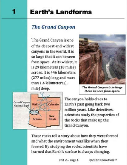
Weathering and erosion are so powerful that they can cause tall mountains to become flat over time. Weathering and erosion can also cut through the land, carving out a canyon so large it can be seen from space.
How can moving water do this? The Colorado River is one of the most powerful rivers in the world. It is so powerful that it can carry large pieces of sediment — including large boulders —in its flow.
The Grand Canyon is so deep because the rocks carried along in the river act like tools. They chip off pieces of the riverbed as they are carried along. This process causes large amounts of rock to be weathered and eroded. Scientists estimate that 1 billion tons of rock have been carved out of the land to form the Grand Canyon.


In this lesson, students carry out an experiment to observe how the steepness of a slope affects the amount of sand eroded by water. Students use the information they gather from the experiment to construct an explanation about how water erodes sand when it moves over a steep slope, a slight slope, or no slope.
KnowAtom incorporates formative and summative assessments designed to make students thinking visible for deeper student-centered learning.

Standards citation: NGSS Lead States. 2013. Next Generation Science Standards: For States, By States. Washington, DC: The National Academies Press. Neither WestEd nor the lead states and partners that developed the Next Generation Science Standards were involved in the production of this product, and do not endorse it.
